CATEGORIES:
A Modern View of Tornado Alley
August 9, 2022

Tornado Alley is a concept that seems simple but is a bit complex.
Traditionally, tornado alley has been depicted as a stripe of states north-south through the Great Plains. The illustration from Wikipedia (below) is typical.

But we now know that depiction is incomplete. The map below, from Tornado Archive, is a new map of all known tornadoes from 1880 to 2019. Note that a significant number of tornadoes have occurred in every state (including Hawaii and Alaska, which are not shown).
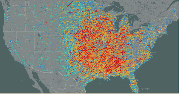
This new map depicts tornado alley as more or less a donut shape with a minimum of tornadoes in Missouri. It surprises many to learn there is a dense area of tornado frequency and strong tornadoes over Mississippi and Alabama, which leads to this surprising result: Where do tornadoes present the greatest threat of death or injury? The map below is from Dr. P Grady Dixon of Kansas’ Ft. Hays State University (reproduced from The Washington Post).
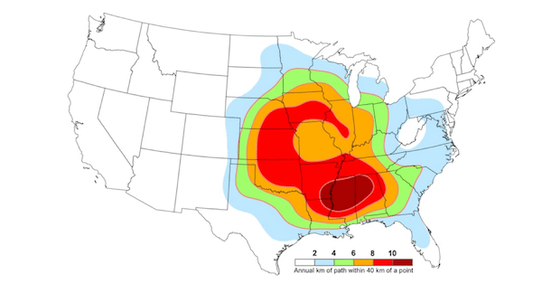
Dixon’s tornado alley map is based on tornado “path-miles.” Where tornadoes are stronger, and on the ground longer, there is a greater risk of death and injury due to a lack of basements and other shelters in the South. Another dangerous element in the South is the higher frequency of overnight tornadoes compared to the rest of the nation.
There has been considerable speculation in the last five years about a “fluctuating” tornado alley – how in recent years, tornadoes have been relatively more frequent in the South in the previous five to eight years as compared to the Great Plains.
The fluctuating tornado alley was first documented in a paper published by Dr. Ted Fujita and two co-authors in 1974, titled, Long-Term Fluctuation of Tornado Activities. There has been considerable additional evidence since.
That scientific paper speculated that drought in the High Plains caused dry air to surge east toward the Ozarks and Midwest, thus displacing east where strong thunderstorms and tornadoes occurred. However, this was based on a computer simulation. The actual data shows the High Plains became wetter during this period. It is more likely that the fluctuations are part of a not-well-understood process discovered during the 1970s.
Based on experience, tornadoes could increase again in the Great Plains. In the meantime, since tornadoes have been documented in all 50 states - it is vital that people throughout the country, especially in the South, have a tornado plan and adequate residential tornado shelters like those made by Survive-A-Storm.
Author