CATEGORIES:
How to Gauge a Tornado Threat: Alerts and Polygons Explained
April 19, 2023

In many areas of the United States, tornado season is well underway. In the Southeast, states like Georgia, Alabama and Tennessee have already had a particularly rough start and they’ll be on edge until June. (And they may have a secondary tornado season in the fall, depending on weather conditions.) Residents of the Central US, in states like Kansas, Oklahoma,and Missouri, know to be alert through the fall.
And, of course, tornados have done damage outside of these timeframes and outside of these regions. It’s a fact that every state in the US has been host to a twister at some point, and will likely be again. One of the most important things to know about a tornado is when you are in danger, based on your location.
Despite many fears and a vast collection of myths around tornadoes, they don’t just drop down out of the clear blue sky. Tornadoes are typically part of thunderstorm systems and storms that can produce tornadoes are tracked by the National Weather Service (NWS). The NWS uses a network of weather radars, satellites, and ground-based observing systems to track storms and gather data on atmospheric conditions. The data is then used to create weather models that help forecasters predict the development and movement of storms.
Tornadoes are produced when atmospheric conditions cause warm, moist air to collide with dry, cool air. It is believed that those conditions, along with a combination of atmospheric instability, wind shear, and the presence of a rotating updraft all play a part.
If you’re in an area experiencing thunderstorms, the National Weather Service may issue an alert. It’s a good idea to know the difference between these two:
1. Tornado Watch
A tornado watch is issued by the NWS when weather conditions are favorable for the development of tornadoes. This could mean humid air, changes in wind speed, or direction, and a warm or cold front. However, this doesn’t mean one has been seen, or that it’s time to go to shelter just yet. It simply means that tornadoes are possible. (Some tornado watches never become warnings.)
2. Tornado Warning
The NWS will issue a tornado warning when one has been spotted or is indicated by radar. That is typically the time when people in the area should be prepared to take shelter and those closest to it definitely should.
If you’ve ever lived in a tornado-prone area, you may have experienced a situation where your county was under a tornado warning, and maybe the tornado sirens even sounded. You went to your designated tornado shelter, only to find out later that the tornado was miles away. When this happens several times, you may get the false sense that next time you could probably wait a little longer to go to your shelter. This is called warning fatigue.
That wait may not be in your best interest. Here’s why.
Tornado Threats and the Polygon Area
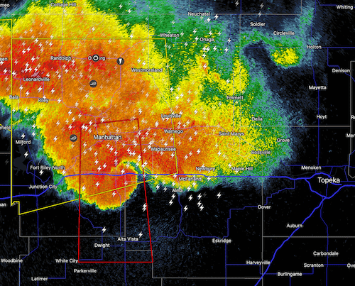 It’s possible that what happened was that the area that was warned about the tornado was larger than the area that was in danger. The NWS outlines a geographic area where the tornado is most likely to occur and draws a line around it, creating the “polygon area.” This is the area where it is imperative to take shelter.
The polygon is created based on a variety of data, including radar, storm reports, and meteorological models. The size and shape are determined by the National Weather Service based on the size and direction of the storm. It gives a visual representation of the potential path of the tornado. It is designed to tell you to take safety precautions, which for a tornado means – get to shelter!
So why is the alert area so often larger than the actual area of danger? One reason is that the polygon is dynamic, or different for every storm, while the areas the alert systems cover are fixed. An alert system may be based on counties, or municipalities, fixed regions (like multi-county, or municipality), or statewide. So, if the storm resides in two alert-area regions, that means traditionally both regions would need to receive the alert.
This is where listening to your local meteorologist is extremely important. They may say things like, “If you live in the northeast part of Osage County, get to your shelter.” Or, “If you live in Mountain Pine, Pearcy, Hot Springs, or any of the areas within the red boundary on the radar, it is time to get to shelter!” In these (fictional) scenarios, the meteorologist is using the NWS polygon.
Location-Based Tornado Alert Solutions
With newer technology, comes newer and better solutions. It is now possible to create systems that warn people based on their location.
One such system is the Wireless Emergency Alerts (WEA) system, operated by the Federal Emergency Management Agency (FEMA). It uses cell broadcast technology to send free alerts to all smartphones that are within the geographic area covered by the tornado warning. Using cell towers, it broadcasts the alert to all smartphones in the tornado warning area. You may have already received a WEA alert if you own a cell phone that is equipped. For WEA alerts, users can check device settings to make sure that "Emergency Alerts" or "Public Safety Messages" are enabled.
In addition to being free, another good thing about WEA is that you can receive an alert no matter where you are at the time. However, the system isn’t as precise as other location-based alerts - it doesn’t solve the issue of sending the alert out to a larger area than the area in danger. You could be at your neighborhood supermarket and receive an alert, only to find out that the tornado is miles away, in another part of the county.
 There are also private tornado alert systems that use GPS technology. One such location-based tornado alert system is Survive-A-Storm’s StormWarn, which is designed to warn its subscribers who live within the polygon area for each storm.
When users subscribe to the service, they enroll their address and provide contact information. When their home is in the polygon area, they will receive a pre-recorded phone call and a text message telling them to go to their shelter. When their area is safe, subscribers to the service will know when to come out of their tornado shelters, since they receive an “all-clear” message and a call.
The best part is - there’s no guessing whether you are in the danger zone. When you get the call or text, it’s time! There’s also an option that allows the subscriber to set up a welfare check that calls the subscriber if, indeed, tornadoes did touch down in their area. In that case, if no answer is received or if the user needs help, local authorities would be notified.
Staying Safe – Start Today
As the season continues to rage on, it's important to ensure you're prepared for tornadoes and have a plan in place for when a tornado warning is issued. Take a moment to think about your family's plan of action. Do you have an emergency preparedness kit and a place to take shelter? Additionally, consider signing up for a location-based tornado alert system, like StormWarn, to receive timely and precise warnings when a tornado is heading your way. With these steps, you can help keep yourself and your loved ones safe during tornado season and beyond.
Author